 |
(The following article was translated into English by artificial intelligence.)
The Best Island Walking Trail
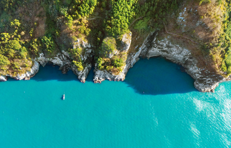
A day spent walking while gazing at the sparkling blue sky and the silver sea beneath the sun until your eyes sting is a happy day. Located in Nammyeon, Yeosu-si, Jeollanam-do, Geumodo Island's 'Bileong-gil' presents such moments as a gift. 'Beleong' is a local dialect of Yeosu, meaning cliff. Bileong-gil translates to 'cliff path' or 'path above the cliff.' Geumodo Island has many coastal cliffs. Coastal cliffs, formed by coastal erosion or changes in sea levels due to climate change, are common on the East Coast but rare on the South Coast. The coastal cliffs of Geumodo Island, combined with rocky cliffs, create breathtaking views. Bileong-gil winds along the coastal cliffs and cliffs. The total length is 18.5 km. With Maebongsan (382m) and Mangsan (343m) between, the elevation of the trail seemed to range from tens of meters to over 200m.
Geumodo Island is part of the Dadohaehaesang National Park. The picturesque views created by the rugged cliffs and clear blue sea continue throughout the Bileong-gil trail. Dense camellia trees and bamboo create deep forests everywhere, almost obscuring the sky. If one were to describe walking along Bileong-gil differently, it might be called 'walking through the islands of Dadohae.' That's how close the islands felt. Bileong-gil is renowned as the best 'island walking' trail.
Until the 21st year of King Gojong in the Joseon Dynasty (1884), Geumodo Island was designated as a 'sealed mountain.' A sealed mountain was a mountain where civilian access was prohibited to cultivate and nurture pine trees used for building or maintaining palaces. It was released from its seal in 1885 when numerous pine trees were toppled by a typhoon. As human habitation on the island has been relatively short, primeval forests are still preserved. It is said that King Gojong gave Geumodo Island as a gift to Empress Myeongseong, hence it is also called the 'Island loved by Empress Myeongseong.' The island was named Geumodo because its shape resembles a large paddle, similar to a boat oar.

From sunrise to sunset, a joyful time... A path suitable for walking even in winter
Bileong-gil is divided into five courses: Course 1 to Course 5. Starting from Hamgumi on the northwest tip of the island and ending at Jangji on the southeast tip, walking all five courses covers the entire western coast of the island. Geumodo Island is not a small island, ranking as the 21st largest in South Korea. Its area is approximately 27 km². Walking along the entire western coast of the island was no easy feat. One couldn't help but slow down their pace, intoxicated by the scenery. Eventually, it was deemed difficult to walk all five courses in one day, so with the help of the Nammyeon Office in Yeosu-si, we drove to the Gujeong Observatory using the paved second course.
Course 1 (5.0 km) starts from Hamgumi to Dupho, Course 2 (3.5 km) from Dupho to Jikpo, Course 3 (3.5 km) from Jikpo to Hakdong, Course 4 (3.2 km) from Hakdong to Simpo, and Course 5 (3.3 km) from Simpo to Jangji. Walking for 30-40 minutes from the starting point of Course 1, Hamgumi, you encounter the first scenic spot of Bileong-gil, called Mieok Neolbang. This is where villagers used to carry and spread seaweed collected from the sea. The altitude of Mieok Neolbang is about 90m. One couldn't help but admire the resilience of the islanders. Bileong-gil is a trail that was refurbished from the paths villagers used to search for firewood. On this path birds used to walk/ And wind used to gasp/... Even amidst such perilous cliffs, there were paths where people walked/ Clinging to the rocks with no place to put their feet/ It was a path where they caught poverty. This is an excerpt from the poem 'Geumodo Bileong-gil' engraved on wooden signs along the path.
Course 1's highlights include Chobun, which reveals the legend of Jinhwasa Temple and offers glimpses of the island's unique funeral customs. According to legend, the monk Bojo found three new lands by sending three birds out to search for a good temple site: Songgwangsa in Suncheon, Songgwangam in Goheung, and one settled on Geumodo Island. This is known as the 'Three Songgwang.' There are records stating that during the reign of King Myeongjong (1195), Jinul established a temple on Geumodo Island in Nammyeon, so this temple site is presumed to be the former site of Songgwangsa.
Chobun refers to temporary gravesites. The bodies were initially placed in these graves and then, after 2-3 years, the cleaned bones were buried in proper tombs, reflecting a traditional funeral practice expressing wishes for rebirth in the next life.
Dupho Village, the starting point of Course 2, is also known as 'Chofu' or 'First Settlement,' meaning it was the first place people settled. Course 3 showcases bizarre-shaped rocks and emerald seas, offering the essence of Bileong-gil's scenery. The path is steep, giving a sense of hiking. Galbam Tower Observatory, Maebong Tower Observatory, and Beleong Bridge are impressive sights. This is a path particularly favored by hiking enthusiasts.
Course 4 is the shortest, attracting many visitors who find hiking burdensome. A long suspension bridge that fascinates travelers was under construction. At the end of Course 5, Jangji Village offers a picturesque view resembling a painting. Ando, shaped like a crane spreading its wings, is connected to Geumodo Island by Ando Bridge. Ando is famous for its natural fishing port, a rural experience village, a forest of pine and camellia trees, and the Crane Path, a pedestrian travel route.
Geumodo Island seemed to be home to various species of birds. The continuous chirping of birds without rest was a delightful chorus for the ears. Despite heading into the heart of winter, the wind was gentle and the sunlight was warm. The peak season for tourism and exploration of Bileong-gil is quite long. It starts in June as summer begins and lasts until November, when the autumn leaves are beautiful. Winter on Bileong-gil was pleasant enough to challenge common beliefs.
Setting off from Yeosu's Singihang Port, we sailed towards Geumodo Island as if being sucked into the sea. By the time we finished our journey in Jangji Village, the sun was setting, showing its reddish face as it descended into the sea. The emotions accumulated from sunrise to sunset turned into a sense of pride as we returned to Singihang, leaving the darkness behind.

Eleven Bridges and Geumodo Island
Before the creation of Bileong-gil in 2010, Geumodo Island was already famous for hiking and fishing. The hiking trail from Hamgumi, passing through Maebongsan and then Oknyeobong (261m), down to the eastern coast at Geombawi, offers a magnificent view of the sea spreading out on both sides. Thanks to the currents coming up from Jeju Island, Geumodo Island is abundant in fish. It is the largest breeding ground for emotional fish in the country, with plenty of red sea bream, rockfish, vermilion snapper, anchovies, eels, and mackerel caught here. There were many fishermen on the boat we boarded.
About 70% of the nationwide production of rockweed, also known as "bangpungnamul" for preventing strokes, is cultivated on Geumodo Island. Rockweed grown on Geumodo Island, enjoying sea breezes and abundant sunlight, has a rich aroma and excellent taste. Rockweed is known as a spring vegetable, making it difficult to maintain sales in winter. It was regrettable to see rockweed abandoned in the fields without buyers.
Yeosu is scattered with 365 islands, including 48 inhabited and 317 uninhabited islands. The islands are connected by modern bridges. The Eleven Bridges project connects islands to each other and to the mainland from Yeongnam-myeon, Goheung, to Dolsan-eup, Yeosu. Seven bridges, including the Pal-yeong Bridge connecting Goheung Yeongnam-myeon and Yeosu Jeokgeumdo, the Jeokgeum Bridge connecting Jeokgeumdo and Nangdo, the Nangdo Bridge connecting Nangdo and Dunbyungdo, the Dunbyung Bridge connecting Dunbyungdo and Jobaldo, the Hwayang-Jobal Bridge connecting Hwayang-myeon and Baekya-do, the Baekya Bridge connecting Hwayang-myeon and Baekya-do, and the Hwatae Bridge connecting Hwatae-do and Dolsan-eup, have already been constructed.
The Hwajeong Bridge (tentative name) connecting Baekya-do and Jedo, the Jedeo Bridge (tentative name) connecting Jedeo and Gaedo, the Gaedo Bridge (tentative name) connecting Gaedo and Wolhodo, and the Wolho Bridge (tentative name) connecting Wolho-do and Hwatae-do are all scheduled to be completed by 2028. The areas these bridges will connect, except for Yeongnam-myeon in Goheung, are all part of Yeosu City, either mainland or islands. Once these eleven bridges are completed, various bridges resembling a bridge museum and jewel-like islands will come together to create a world-class maritime tourism belt. The construction of the Yeondo Bridge, connecting Wolho-do and Geumodo Island, is also underway. With the completion of the Yeondo Bridge, Geumodo Island will be connected to the mainland. A submarine tunnel connecting Namhae in Gyeongsangnam-do and Yeosu is also under construction. The day Bileong-gil approaches us is not far off.

(C) Yonhap News Agency. All Rights Reserved