Following my last column on my visit to Pyongyang two decades ago, I now share the highlight of that trip: the journey to Baekdu Mountain.
The distance from Pyongyang’s Sunan Airport to Samjiyon Airport is 480 km, yet even with an old four-engine propeller plane, the flight takes less than an hour. Samjiyon is at an altitude of 1,800 meters, so there are only 800 meters left to reach Baekdu’s 2,700-meter peak. From here, a two-lane road leads up, and after an hour and twenty minutes of driving, you reach the summit overlooking Heaven Lake.
Though remnants of snow linger, the roads have cleared, making the ascent unexpectedly easy. Soldiers are repairing what seems to be an "inkra"—presumably referring to an inclined lift used when snow is heavy. From the car drop-off, it's just 200–300 meters to the top of Janggunbong Peak, or you can take a cable car down to the shores of Heaven Lake.
I hadn’t imagined that the path to Baekdu Mountain would be so well-maintained, making it accessible with such ease. Despite forecasts predicting early winter weather, the sun shone brightly, warding off any chill. Locals were quick to say that this clear weather was a stroke of fortune.
One visitor, I learned, had to descend to Samjiyon without seeing the lake due to dense clouds and returned several times, four in total, before finally giving up. It seems we were exceptionally lucky. Knowing firsthand how unpredictable mountain weather can be, I took a moment to sit, grateful for the breathtaking view.
The overwhelming emotion was beyond words. The journey unfolded like a film, or a panoramic photograph: we had passed through ancient coniferous forests near Samjiyon, entered an open landscape of wind-sculpted juniper trees typical of high altitudes, followed by vast meadows of wildflowers, and finally reached stark volcanic ridges resembling the surface of the moon.
It was as though this scenery—like a series of images from a wide-angle camera—had imprinted itself on my mind and, more profoundly, my heart.
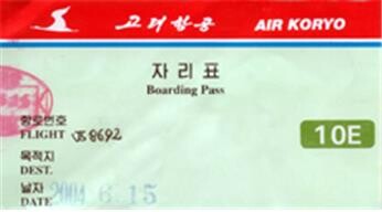 |
| ▲ The North Korean flight ticket to Pyongyang, taken and provided by the author. (PHOTO NOT FOR SALE) (Yonhap) |
They say that only recently did the snow atop Baekdu Mountain's peak, usually covered year-round, begin to melt. This left patches of remaining snow scattered across the mountain in various piles. Even Heaven Lake itself, frozen as recently as three days ago, is only now thawing, with chunks of ice still floating on its surface.
As for the vast fields of wildflowers we passed earlier, it was mid-June at the time of our visit, marking the start of the blossoming spring season. But by August, colder weather would set in, and climbing would be prohibited. This brief season perfectly reflects Baekdu Mountain's reputation as a peak crowned by snow throughout the year.
It has been nearly 80 years since my father came to this place and, overwhelmed by the scene, sent a postcard drawing of it to his two young daughters, aged ten and six. In the long years since then, the sight of this sacred mountain and its lake remained completely inaccessible to people from the South. Decades ago, I obtained a large framed black-and-white photo of Heaven Lake on Baekdu Mountain, and I cherished it. But now, this grand panorama—once only an image in a photograph—is here before me in vivid reality, not a dream. Judging by the printing technique, those photos must have been taken 80 to 100 years ago, yet the scene remains unchanged, a testament to nature’s timeless harmony.
The area is predominantly occupied by military personnel, with civilian access strictly controlled. Given the mountain’s location along the border with China, these soldiers are likely stationed to guard the boundary, making it understandable that civilians are not freely allowed to wander near the border.
An elegantly dressed young female soldier, wearing a shoulder-mounted microphone, approaches to give an extended presentation. She emphasizes that our visit coincides with the fourth anniversary of the June 15 South-North Joint Declaration and passionately speaks of the desire for national reunification.
Although some may criticize or oppose the Sunshine Policy and the June 15 Declaration, the very fact that I am here today underscores their significance.
Listening intently, I take in her explanations on the height of the mountain, the lake’s circumference and depth, the volcano’s formation, and even the fish that inhabit the lake. She tells of the mountain trout, which were released ten years ago and have now grown to 75 cm, with some presented as a gift to the "Great Leader."
One final glance around, however, reveals something disconcerting: the prominent inscription carved into the cliffside, reading, “The Sacred Mountain of National Revolution, Kim Jong-il.” Such a slogan, stark against the natural landscape, makes me furrow my brows.
According to explanations provided, volcanic activity on Baekdu Mountain began around the Jurassic period (approximately 600 million years ago), persisting through the Tertiary and Quaternary periods of the Cenozoic Era. This activity created an extensive lava field spanning roughly 5,350 square kilometers. About 2 million years ago, volcanic eruptions began to subside, eventually shaping the current mountain landscape.
The most recent eruptions occurred in 1597, 1668, and 1702. Even today, minor tremors measuring 2 to 3 on the Richter scale occur within a 50-kilometer radius of the summit. This vast lava field, formed from volcanic ash, volcanic bombs, and volcanic sand, endures winter-like conditions for roughly 230 days of the year, so only hardy alpine plants such as creeping thyme, Siromi (a term derived from Jeju dialect meaning "Siroonggae"), rock chrysanthemums, rhododendrons, and wild blueberries (the source of the renowned Baekdu wild blueberry liquor) grow on the upper slopes.
Descending from the peak, Baekdu birch, spruce, and larch trees, which existed before the area experienced volcanic activity, are sparsely distributed near Jongil Peak and in select areas.
Heaven Lake, true to its name, resembles a celestial pond. With a surface area of 9,200 square kilometers and a maximum depth of 384 meters, its deep blue water seems almost sacred, surrounded by barren, rocky mountains like the surface of the moon.
The feeling here is completely different from Hallasan's Baengnokdam. Everything from the lake's size to its hue, combined with the altitude’s thin air that makes even slight movements feel strenuous, gives this place a unique sense of awe. This grand lake at an altitude of 2,700 meters seems unlikely to be filled just by rainwater; rather, it feels as if some tremendous force pushed groundwater up from the depths.
Many people refer to such a sight as "the mystery of ancient times," and indeed, it is easy to understand why our ancestors venerated this mountain as sacred for centuries.
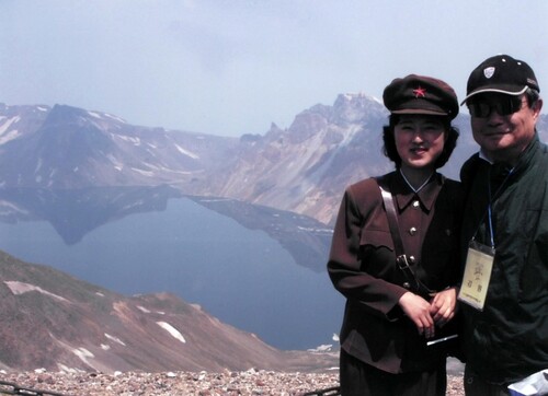 |
| ▲ This photo, taken and provided by the author, shows him (R) posing with a North Korean guide for photos at Cheonjiyeon, meaning "Heaven Lake," a volcanic crater lake atop Mount. Baekdusan. (PHOTO NOT FOR SALE) (Yonhap) |
The Korean Peninsula’s spine, Baekdu-daegan, originates from here, extending southward like the backbone of the land, spanning 3,000 ri from north to south and westward. The Tumen and Amnok Rivers also have their sources here, marking the border between Korea and China. Hence, this area, formerly part of North Hamgyong Province, is now called "Ryanggang Province," or “Province of the Two Rivers.”
On the Chinese side, Changbai Falls flows into the Erdaobai River and eventually joins the Songhua River.
The Boundary Stone, erected in 1712 during the 38th year of King Sukjong's reign, marks the agreed border between Korea and the Qing Dynasty.
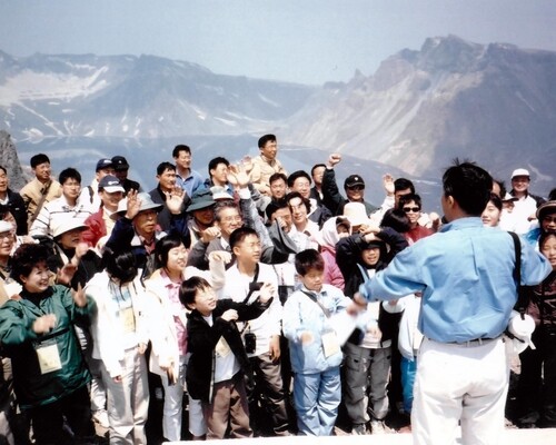
The guide explained that, despite much of this area once belonging to China, North Korea has since reclaimed it. Gathered at the summit, we observed a moment of silence and raised cheers for reunification in commemoration of the fourth anniversary of the June 15 Declaration. A surge of emotion welled up from the depths of my heart.
A distant thunder rumbles from far away. The guides, constantly checking their watches, hasten our descent, fearing that a storm may soon approach. Reluctantly, we bid farewell to the sacred mountain and lake, climbing into the car.
I wonder when I will be able to return to this place. When will my children and grandchildren be able to visit here freely? These thoughts make me feel a little sad. Perhaps that's why the atmosphere among our group grows quiet and somber.
I picked up three small volcanic stones of different sizes and shapes from the ground, placing them into my camera bag as mementos to take back south. It was a good decision. I also noticed cigarette butts and empty coffee cans scattered around and decided to clean up before leaving, which also felt like the right thing to do.
The guide, who had been watching us, smiled and said, "During the 2002 World Cup, I saw how the large crowd cleaned up so well."
On the way down, a different road opened up. We parked the car in a meadow resembling the wildflower fields we had passed two hours earlier, and enjoyed a late lunch with the packed meals we had brought. The box, labeled "Koryo Hotel," was a high-quality meal, akin to a Shilla Hotel lunch box in our country.
We sat surrounded by unknown mountain flowers, savoring the delicious food with a sense of bliss. The yellowish-white flowers, known as "Manbyeongcho," are the most common and beautiful here. They are also the main ingredient in North Korea's popular "Baekdu Mountain Manbyeongcho Liquor."
The red flowers, believed to be "Mountain Azaleas," seem unbelievable. This is an area where further study is needed. The thorn bushes resembling "Sirungge" (known in Jeju dialect as "Siromi," which might also be the same) found above 1,500 meters on Hallasan are much more familiar to me.
The children flew kites. The strong mountain winds lifted the kites high into the sky. Though the sunlight was blinding, we could hear thunder again in the distance, and black clouds were quickly gathering beyond the eastern ridge.
 |
| ▲ This photo, taken and provided by the author, shows the tourist team posing for photos at Cheonjiyeon, meaning "Heaven Lake," a volcanic crater lake atop Mount. Baekdusan. (PHOTO NOT FOR SALE) (Yonhap) |
As soon as we got back in the car and started our descent, raindrops began to fall, quickly turning into hail, accompanied by strong winds, thunder, and lightning that hammered on the car windows. Soon, piles of hail accumulated along the roadside. It is said that strong winds blow here for about 270 days a year, with typical gusts reaching 40 meters per second, and that whirlwinds, known as "dragon winds," are common, so this amount of hail is nothing extraordinary.
On the way down, several waterfalls caught our attention, including Baekdu Waterfall, Sagi Mun Waterfall, Brother Waterfall, and Milyeong Waterfall. Each one is an immense tourist resource.
In the rain, we arrived at the so-called "Baekdu Mountain Milyeong." The term "Milyeong" refers to a "secret military camp," and it is said that after Kim Il-sung returned to his homeland and organized the independence army, he secretly trained his troops and reorganized them here, preparing for battle. During this period, his wife, Kim Jong-suk, gave birth to Kim Jong-il, which is why they consider this place a sacred site.
During a particularly harsh time with extreme cold, food and clothing shortages, soldiers are said to have pulled small amounts of cotton from their underwear to create a baby carrier for the newborn, a heart-wrenching story that is still passed down. The "carrier" is now displayed here.
Despite the beautiful scenery, the massive red characters on the towering rock peak behind Milyeong that read "Jeongil Peak" (정일봉) are jarring to the eyes.
Afterward, we returned to Samjiyeon. In addition to the airport, Samjiyeon has become another "republic" sacred site. The area, located at an altitude of 1,800 meters, is known for its beautiful landscape where three interconnected lakes can be found.
Kim Il-sung, after leading the army trained in Milyeong, came to Samjiyeon to prepare for the famous "Pochonbo Battle," where he achieved a great victory. For this reason, it has been developed as a sacred site for the independence movement. A massive statue, believed to be the second largest after the one in Pyongyang, has been erected here, surrounded by statues of soldiers and the people.
The sculptures are a typical example of 'Social Realism,' but they are crafted with excellent technique. The artist was highly praised during Kim Il-sung's lifetime and was honored as a People's Artist.
It seems the creation of an airport in Samjiyeon was part of a dual purpose: to turn the area into a pilgrimage site for the "Great Leader" and to serve as a base for ascending Baekdu Mountain. Many triangular-roofed bungalow-style buildings are being constructed in the forests near Samjiyeon, some of which appear to be hundreds in number. These are not military barracks, yet soldiers are working there.
Curious, I asked the guide about it. "Well, I don't know. Perhaps they're relocating farmers from somewhere?" was the vague response, which sounded like a lie to me.
In my opinion, these are likely to be part of a construction project for tourist bungalows in preparation for the full-scale tourism of Samjiyeon and Baekdu Mountain.
Indeed, if we sleep at a place around this distance, we can depart early enough to catch the sunrise from the summit of Baekdu Mountain. I deeply hope that such a day, when we can enjoy this kind of sightseeing, will come again in the near future.
If the North Koreans viewed our trip as a practice run for attracting large-scale tourist groups from the South, preparing for future visits, then that attempt can be considered a success.
We were deeply moved, and they can certainly report to their superiors that they successfully showcased their sacred sites to key figures from the South, evoking great emotion.
Thanks to the guides' diligent explanations, we clapped our hands at the end of every briefing as a matter of course, but to them, it may have sounded like applause filled with emotion.
In any case, for South Koreans who shed tears of joy just by managing to visit Baekdu Mountain through China, this easy day-trip to Baekdu Mountain, regardless of the cost, would be highly welcomed. Even though the aircraft, a Soviet-made twin-engine propeller plane, is old, the special plane waiting exclusively for us on the runway, rather than a regular commercial flight, was undoubtedly a heartwarming gesture.
(C) Yonhap News Agency. All Rights Reserved


![[박스오피스]](/news/data/20260112/yna1065624915979156_480_h2.jpg)